
The tropical rain belt is responsible for a significant portion of the rainfall that occurs in the tropics. How much so can be seen in the following photograph showing 30 day rainfall averages:

Formerly, meteorologists referred to the entire tropical rain belt as the intertropical convergence zone (ITCZ). Today, more and more meteorologists are restricting use of this term to refer to that part of the tropical rain belt found over oceanic regions (see below for why) and it is in this sense that I’ll be talking about it.
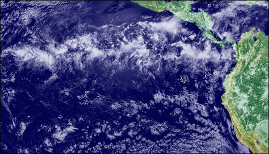
From space, the ITCZ is often visible as a rough band of cloudiness (up to 300-500 nautical miles wide) that is generally tropical in location and roughly parallels the equator. Below is a photograph showing part of the ITCZ in the eastern Pacific:
The ITCZ is often associated with rainfall in the form of showers or atmospheric convection. Atmospheric convection? On land, atmospheric convection is basically synonymous with thunderstorm. That’s not the case over the open ocean. Meteorologists have recently come to realize that the amount of lightning a storm produces is related to the strength of the storm’s updrafts and downdrafts. Apparently, updrafts and downdrafts in oceanic cumulonimbus clouds aren’t as strong as they are in cumulonimbus clouds on or near land. Consequently, despite towering as high and often higher, oceanic cumulonimbus clouds aren’t nearly as apt to produce lightning and associated thunder. Since the ITCZ is now being thought of as a climatic feature largely limited to oceanic areas, it wouldn’t be entirely accurate to say that it is frequently associated with thunderstorms.