The tropical rain belt is responsible for a significant portion of the rainfall that occurs in the tropics. How much so can be seen in the following photograph showing 30 day rainfall averages:
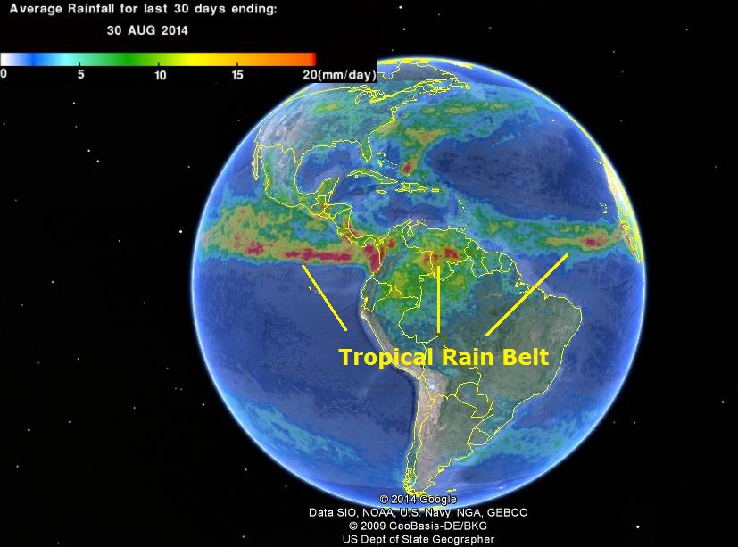
Formerly, meteorologists referred to the entire tropical rain belt as the intertropical convergence zone (ITCZ). Today, more and more meteorologists are restricting use of this term to refer to that part of the tropical rain belt found over oceanic regions (see below for why) and it is in this sense that I’ll be talking about it.
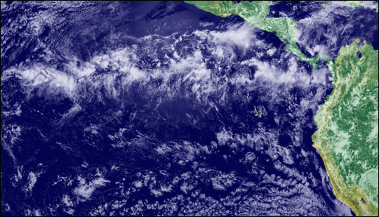
From space, the ITCZ is often visible as a rough band of cloudiness (up to 300-500 nautical miles wide) that is generally tropical in location and roughly parallels the equator. Below is a photograph showing part of the ITCZ in the eastern Pacific:
The ITCZ is often associated with rainfall in the form of showers or atmospheric convection. Atmospheric convection? On land, atmospheric convection is basically synonymous with thunderstorm. That’s not the case over the open ocean. Meteorologists have recently come to realize that the amount of lightning a storm produces is related to the strength of the storm’s updrafts and downdrafts. Apparently, updrafts and downdrafts in oceanic cumulonimbus clouds aren’t as strong as they are in cumulonimbus clouds on or near land. Consequently, despite towering as high and often higher, oceanic cumulonimbus clouds aren’t nearly as apt to produce lightning and associated thunder. Since the ITCZ is now being thought of as a climatic feature largely limited to oceanic areas, it wouldn’t be entirely accurate to say that it is frequently associated with thunderstorms.
So what causes the ITCZ? That’s a question that can be answered on a number of different levels. This posting, however, will primarily focus on what is believed to initiate atmospheric convection there. Before I address this question, though, I think it is worth developing an intuitive — if somewhat simplified — understanding of how atmospheric convection is initiated for those who aren’t familiar with the process.
There are two things we need to first establish. First, while it is not always the case, most of the time air temperature decreases with increasing altitude. How rapidly the atmosphere cools with increasing altitude is a function of various meteorological processes and is called the environmental lapse rate. Second, air has a natural tendency to rise only when it is lighter than the air around it. So just because air is warmer (and lighter) at the earth’s surface than above, it doesn’t mean that this warm air is going to rise.
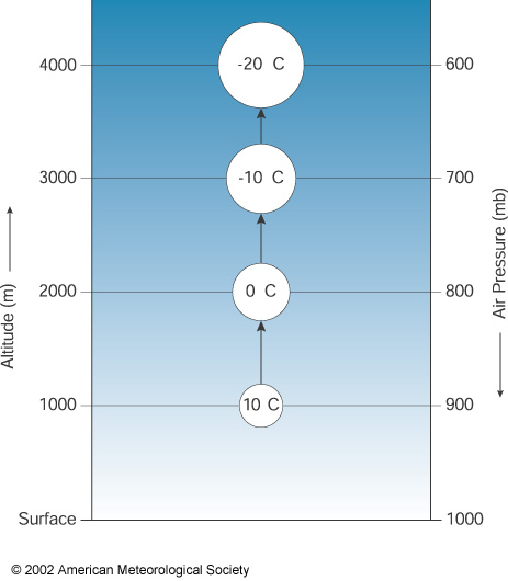
Now let’s consider two extremes. In the first, air temperature decreases very slowly with increasing altitude and the air at the earth’s surface is very cool and dry (and consequently, dense). Now imagine some perturbation that pushes some (a parcel) of this air at the earth’s surface upward and we’ll assume that for the most part this parcel of air doesn’t mix with the surrounding air. As this parcel of air rises it experiences less air pressure and begins to expand. As shown below, this expansion cools the air in the parcel.
The rate at which cooling occurs in our parcel of air is called the dry adiabatic lapse rate and is equal to 9.8°C per 1000 meters. This cooling will cause the air temperature in this lifted parcel of air to eventually match or even become lower than the temperature of the air surrounding it. So, it will stop rising and may even sink.
In the second extreme, air temperature decreases rapidly with increasing altitude and the air at the earth’s surface is very warm and moist. Both warmth and water vapor decrease the density of air making it more buoyant. We didn’t talk in the first scenario about how strong a perturbation has to be to lift air, but suffice it to say, it doesn’t have to be as strong in this second case as in the first.
So what happens when a perturbation lifts a parcel of surface air in this second scenario? Like in the first scenario, air pressure will decrease with increasing altitude causing the air in the parcel to expand and cool at the dry adiabatic rate. At some point, though, the temperature in the parcel of air will reach its dew point and condensation will occur. Condensation results not only in the formation of clouds but also releases heat. So now the air temperature of the lifted parcel of air is a function of both cooling as a result of expansion associated with increasing altitude and warming as a result of condensation. As long as condensation occurs, the air will cool at what is called the moist adiabatic lapse rate which is 6°C per 1000 meters which means it will now cool slower with altitude by 3.8°C per 1000 meters.
The critical questions then are: how high does the perturbation lift the parcel of air and how does the resulting air temperature of the parcel of air compare to that of the surrounding air in the atmosphere (given by the environmental lapse rate)? In the figure below, if the perturbation lifts the parcel of air sufficiently, it will have a higher temperature than that of the surrounding air. If this happens, like with a hot air balloon, the parcel of air will now rise of its own accord as a result of the heating by condensation. The altitude at which this occurs can be seen in the figure below and is called the level of free convection.
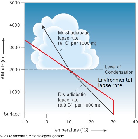
If the parcel of rising air continues to be warmer than the surrounding air as it rises, this process will continue and additional warm, moist air from below will rush in to fill the space left by the rising parcel of air. The result will be the formation of a towering cumulonimbus cloud.
So now back to the ITCZ and why I am writing this article in the first place. In the tropical ecology course that I teach for ITEC, I use John Kricher’s book Tropical Ecology. In it, Kricher explains the weather associated with the ITCZ as follows: “At the equator, heat builds up, and therefore the air rises, carrying warmth. Water is evaporated [from the surface of the ocean], and therefore water vapor rises as well. The warm moist air is cooled as it rises, condensing the water, which then falls as precipitation, accounting for the rainy aspect of tropical climates”. Kricher then goes on to connect all this to Hadley cell structure.
Before continuing, I should point out that the biggest problem with this passage from Kricher lies not with its discussion of why it rains at the ITCZ but in its failure to relate evaporation to heat transfer. Water vapor isn’t just traveling up with warm air at the ITCZ, it actually contains most of the heat (known as latent heat of evaporation) that’s actually being transferred from the ocean surface to the atmosphere.
As to why it rains so much at the ITCZ, I suspect most biologists explain the rainfall associated with the ITCZ something like Kricher does. After all, we are biologists not meteorologists. But if you think about things a bit, such an explanation is not a very satisfying one. As I have already pointed out, just because air is warm does not mean it is going to rise; a parcel of air has to be warmer than the air surrounding it before it will rise. It is certainly true that as you move in both directions from the ITCZ air temperatures will decrease. This drop in temperature with latitude, though, would seem to be far too gradual to initiate atmospheric convection.
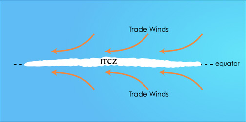
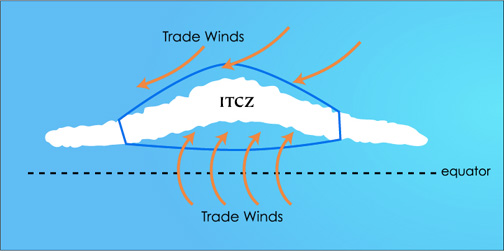
What’s nice is that a better explanation for why it rains at the ITCZ isn’t a brain twister and can even help us better understand other weather phenomena affecting parts of the tropics. Most meteorologists now agree that the atmospheric convection associated with the ITCZ is initiated when easterly winds from subtropical high pressure systems in the Northern and Southern Hemispheres converge (which, by the way, is why the ITCZ is called what it is). If this convergence is sufficiently direct, these warm moisture-laden winds collide. When this happens the colliding air cannot go downward into the ocean and so has to go up. In doing so it is the “perturbation” that we’ve been looking for that lifts air to altitudes where atmospheric convection can occur.
The diagrams below show how the degree of convergence affects the degree of atmospheric convection. In the first diagram, convergence isn’t very direct and either weak or no atmospheric convection occurs.
Where convergence is more direct, more atmospheric convection is predicted. In the extreme, easterlies may cross the equator where they eventually become westerlies as a result of the Coriolis effect. When this happens, as in the case below where southern hemisphere easterlies are crossing the equator, these newly formed westerlies can even impart “spin” when they converge with northern hemisphere easterlies, something that may contribute to tropical storm formation.
It is important to realize that while wind convergence initiates atmospheric convection in the ITCZ, it is possible that much or most of the atmospheric convection there is caused by processes whereby existing storms produce additional ones. Also, if you start looking up information online about the ITCZ, you’ll see mention of double ITCZs. Apparently it’s not unusual to see two zones of cloudiness/rainy weather running parallel to one another. Obviously, convergence of easterlies cannot explain these. However, a high pressure ridge is typically found between a double ITCZ, so converging winds are probably still initiating atmospheric convection in both ITCZs.
Why are meteorologists now restricting use of the term ITCZ to mostly oceanic portions of the tropical rain belt? For one thing, the tropical rain belt is often less defined over land than over the oceans (see the first photograph above). For another, the tropical rain belt over land is often found at quite different latitudes than the corresponding ITCZ over the ocean. Lastly and most importantly, while the convergence of easterlies over the ocean initiates atmospheric convection there, convergence of easterlies over land is often weak to non-existent. Atmospheric convection there must be initiated by other processes like uneven heating of different areas of land (thermals) or outflow from other storms.
SOURCES
Groenemeijer, P., A. Punkka, and J. Teittinen (n.d.). Forecasting Severe Convective Storms. Retrieved from http://www.estofex.org/guide/.
Intertropical convergence zone, ITCZ (n.d.). Experimental Aircraft Info. Retrieved from http://www.experimentalaircraft.info/wx/itcz.php.
Kricher, J. (2011). Tropical Ecology. Princeton, NJ: Princeton University Press.
Space research and observations (n.d.).Lightning & Atmospheric Electricity Research at the GHCC. Retrieved from http://thunder.msfc.nasa.gov/otd/index.html.
Vasquez, T. (2009, Nov.- Dec.). The Intertropical Convergence Zone. Weatherwise: The Power, the Beauty, the Excitement. Retrieved from http://www.weatherwise.org/Archives/Back%20Issues/2009/Nov-Dec%202009/full-Intertropical-Converge.html.

Pingback: A tropical cyclone in Panama and the unusual case of Typhoon Vamei | Where the Rare Wood Still Grows